
Magnitude 6.7 earthquake shakes Junín and is felt strongly in Lima
Peru's central highlands moved on Friday night and the whole country felt it. According to the Geophysical Institute of Peru (IGP), a magnitude 6.7 earthquake with its epicenter 30 kilometers northwest of the city of Junín — 129 kilometers deep — reached intensity V in Junín, was perceived as moderate to strong in the area and was felt in Lima and across much of Peru. Indeci reported that, as of this moment, no personal or material damage has been reported, and the Peruvian Navy ruled out a tsunami alert. The explanation for that combination — high magnitude, enormous reach, no damage so far — is the depth.
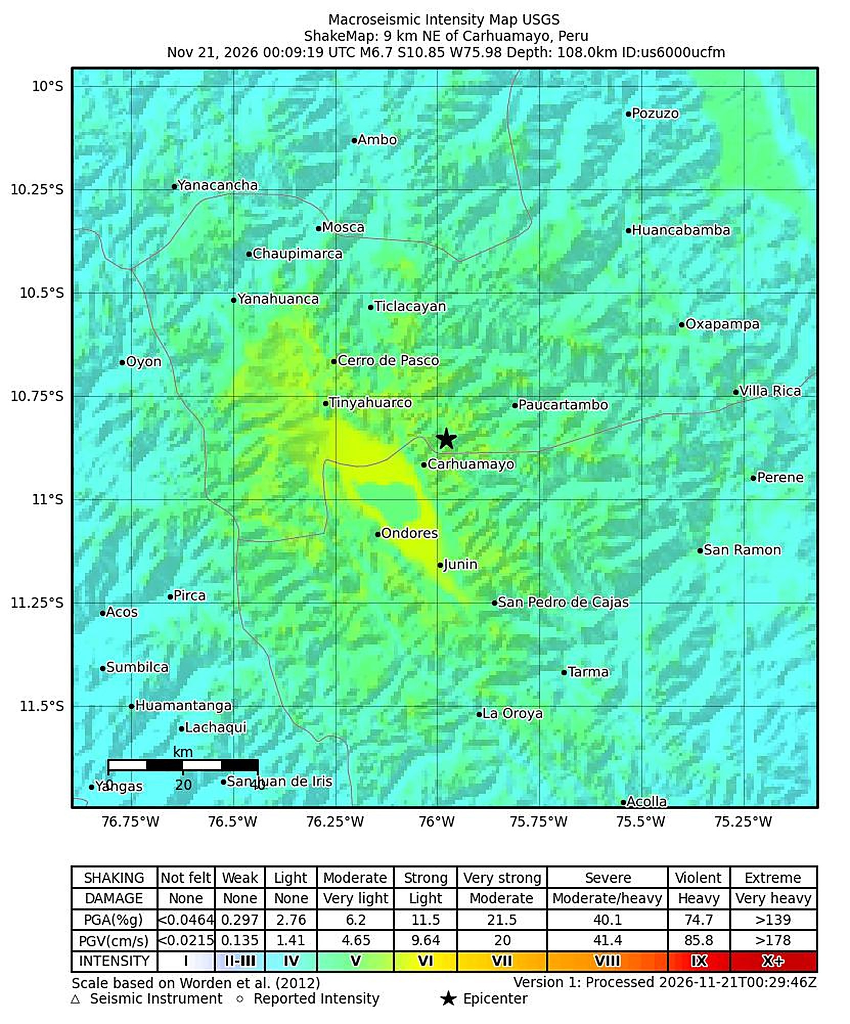
Map: USGS — ShakeMap of event us6000ucfm, “M 6.7 – 9 km NE of Carhuamayo, Peru.” The IGP located the epicenter 30 km northwest of the city of Junín, at a depth of 129 km.
Friday night shook across Peru. At 7:09:19 p.m. local time, a magnitude 6.7 earthquake struck the department of Junín in the country's central highlands and was felt strongly in Lima and across much of Peru. The Geophysical Institute of Peru (IGP) placed the epicenter 30 kilometers northwest of the city of Junín, at latitude −10.97 and longitude −76.19, and set the depth at 129 kilometers. In Junín, shaking reached intensity V on the Modified Mercalli scale — the level felt by nearly everyone, strong enough to wake sleepers and shift unstable objects.
The official balance so far is the part that matters: as of this moment, no personal or material damage has been reported, according to Indeci, Peru's civil defense institute, and there is no tsunami alert. The Peruvian Navy ruled out a tsunami threat for the coast, and the Pacific Tsunami Warning Center issued only an information bulletin. A magnitude 6.7 felt across half a country that, so far, leaves no damage behind: the explanation for that combination sits in a single number in this story — the depth.
What the official record says
The IGP's seismic report — IGP/CENSIS/RS 2026-0818 — is the governing document of this story. It records the magnitude of 6.7, the exact time, 7:09:19 p.m. on Friday, November 20, the epicenter 30 kilometers northwest of the city of Junín and the depth of 129 kilometers. The IGP also reported intensity V in Junín and described shaking in the area as moderate to strong, with the earthquake felt in Lima and across much of the national territory.
The U.S. Geological Survey (USGS) recorded the same event and located the epicenter near Carhuamayo, in the same part of Junín province. The USGS revised its initial magnitude calculation from 6.9 to 6.7 — the figure that matches the IGP's and the one this magazine prints as its own. When two independent seismic networks converge on the same magnitude, the number stands: this was a 6.7.
The number that organizes the story: 129 kilometers down
A magnitude 6.7 earthquake with its epicenter beneath a city and at shallow depth would be a different story. This one happened 129 kilometers below the surface, and that vertical distance changes everything else. Seismologists classify events between roughly 70 and 300 kilometers as intermediate-depth earthquakes: they are not born in the crust, near people's homes, but inside the oceanic plate as it sinks beneath the continent. The energy released has to travel through more than a hundred kilometers of rock before it reaches the surface, and on that journey it spreads across a far wider area.
That spreading explains both faces of tonight's event. The first: the earthquake was felt far away — in Lima and across much of the country — because the energy did not concentrate at one point but extended over an entire region. The second: near the epicenter, intensity held at V, a level that frightens and is remembered, but sits below the levels at which the Mercalli scale begins to record structural damage in vulnerable buildings. Magnitude and intensity do not measure the same thing: magnitude is the event's total energy; intensity is what that energy does in each place when it finally arrives. At 129 kilometers deep, a 6.7 reaches the surface attenuated and spread out.
That is why the sentence that organizes this story is not the magnitude but the full combination: magnitude 6.7, 129 kilometers deep, intensity V at the epicenter zone. Any one of those figures without the other two would tell a different — and worse — story.
No tsunami alert: the reason is geography
The tsunami question arrives every time Peru shakes, and this time the answer was fast and negative. The Peruvian Navy ruled out a tsunami alert for the coast. The reason is the event's geography: the epicenter is inland, beneath the central highlands, and 129 kilometers deep. A tsunami is born when an earthquake vertically displaces the ocean floor; a deep focus under the mountain range does not move the sea.
The Pacific Tsunami Warning Center issued only an information bulletin — the level of communication that records an event without activating any threat — consistent with the same reading: a continental, deep epicenter. For people on the coast, the practical conclusion is simple: there is nothing to do about the sea tonight.
Indeci: no personal or material damage as of this moment
Indeci, the National Civil Defense Institute, reported in its Press Release No. 383-2026 that as of this moment, no personal or material damage has been reported as a result of the earthquake. The caution in that phrase is part of the fact, and this magazine reproduces it exactly: "as of this moment" means the official assessment is under way and the balance can be updated if authorities in the area report developments in the coming hours.
What the record shows so far is consistent with the physics of the event: a very deep focus, a maximum intensity of V, and an extremely wide perception with the energy spread out. It is the profile of an earthquake that becomes the conversation of an entire country for a night — without necessarily becoming an emergency. The final word belongs to Indeci's assessment once it completes its rounds of the communities nearest the epicenter, and any change in that balance will be news on this same page.
A country living on a subduction zone
Peru sits on one of the most active tectonic margins on the planet: the Nazca plate sinks beneath the South American plate off the Peruvian coast, in a continuous process that built the Andes mountain range and releases its energy in earthquakes of every size. The IGP's network, through its National Seismological Center (CENSIS), records that activity permanently: the great majority of events are imperceptible or minor, and those of a magnitude comparable to tonight's are the ones that test the country's seismic memory.
Intermediate-depth earthquakes like this one are a category of their own in the Peruvian catalog. They are born inside the already-subducted Nazca plate as it deforms beneath the continent, and their signature is exactly tonight's: very wide perception, moderate surface intensity. They are not the earthquakes that have done the most damage in Peru's history — that place belongs to the great shallow events off the coast — but they are among those whose shaking covers the most territory, which is why a night like this is felt, at the same time, in Junín, in Lima and across much of the country.
What is known so far
- A magnitude 6.7 earthquake was recorded on Friday, November 20, 2026, at 7:09:19 p.m. Peru time, according to seismic report IGP/CENSIS/RS 2026-0818.
- The epicenter was located 30 kilometers northwest of the city of Junín, in the department of Junín, central highlands; the USGS placed it near Carhuamayo, in the same area.
- The depth was 129 kilometers: an intermediate-depth earthquake.
- Intensity reached V in Junín on the Modified Mercalli scale; shaking was perceived as moderate to strong in the area and was felt in Lima and across much of the country.
- The USGS revised its initial magnitude calculation from 6.9 to 6.7, the figure that matches the IGP's.
- The Peruvian Navy ruled out a tsunami alert; the Pacific Tsunami Warning Center issued only an information bulletin.
- Indeci reported (Press Release No. 383-2026) that, as of this moment, no personal or material damage has been reported.
What is not known
- The final balance of Indeci's assessment in the rural communities closest to the epicenter, which is still under way.
- Whether perceptible aftershocks will be recorded in the coming hours — the IGP maintains permanent monitoring of the area.
- Whether the IGP or the USGS will make further adjustments to the magnitude, epicenter or depth once the event analysis is complete.
This story remains under active follow-up. We are watching for any update from Indeci or the IGP to the balance or the event's parameters.
Published on Friday, November 20, 2026.
𝐆𝐄𝐓 𝐅𝐑𝐄𝐄 𝐅𝐔𝐋𝐋 𝐌𝐀𝐆𝐀𝐙𝐈𝐍𝐄 𝐀𝐓 thebuyerspulse.com
Sources
- Geophysical Institute of Peru (IGP), November 20, 2026: seismic report IGP/CENSIS/RS 2026-0818 — magnitude 6.7; 7:09:19 p.m. local time; epicenter 30 km northwest of the city of Junín (−10.97, −76.19); depth of 129 km; intensity V in Junín.
- Indeci, November 20, 2026: Press Release No. 383-2026, published on gob.pe — as of this moment, no personal or material damage has been reported.
- USGS: event us6000ucfm, “M 6.7 – 9 km NE of Carhuamayo, Peru” — epicenter near Carhuamayo; initial magnitude calculation revised from 6.9 to 6.7; intensity map (ShakeMap) illustrating this page.
- Peruvian Navy: tsunami alert ruled out for the coast. Pacific Tsunami Warning Center: information bulletin, no threat.